Nearly half of the supposed safe havens of marine protected areas are infiltrated by industrial fishing vessels—many operating in the shadows beyond public scrutiny.
In the race to protect our oceans from the mounting pressures of overexploitation and ecological decline, countries worldwide have rapidly increased the designation of marine protected areas (MPAs)—patches of the sea set aside to nurture marine biodiversity and restore dwindling fish populations.
In recent years, MPAs have gained in popularity, with vast areas being designated as ‘protected’, thus boosting public perception of policymakers in the wake of climate change and the ongoing 6th mass extinction event.
Yet, a new global study published in Science by Raphael Seguin and colleagues from the Université de Montpellier, BLOOM, and their partners, suggests the reality of protection isn’t quite what everyone expected.
Analyzing data gathered between 2022 and 2024, the research team deployed a blend of high-resolution satellite imagery, global vessel tracking systems, and artificial intelligence to peer into 6,021 coastal MPAs spanning every continent. Their approach harnessed both public automatic identification system (AIS) signals, commonly used to track large fishing vessels, and synthetic aperture radar (SAR) satellites, which can spot ships that switch off their trackers—a tactic often associated with illicit activities.
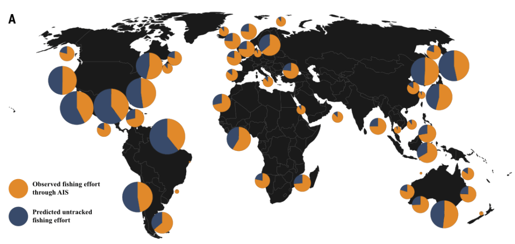
The results show almost half (47%) of all coastal MPAs host industrial fishing vessels, contrary to international guidelines stating such activity should be banned inside these boundaries. Perhaps even more unsettling, two-thirds (67%) of detected vessels in MPAs weren’t being tracked by public monitoring systems, and in the most restrictive MPAs—where all extraction is theoretically forbidden—an astonishing 80% of vessels detected were “untracked”. Factoring in these “dark” vessels increased the estimated fishing effort within MPAs by 28%, driving the average fishing pressure to 4 hours per square kilometer per year—far higher than previously reported.
Large and easily accessible protected areas, especially those near cities or productive fishing grounds, saw the greatest intrusion. This pattern, the researchers suggest, may reflect “residual” MPA placement—where nations declare protected areas in locations that represent the least disruption to industrial activity, inadvertently leaving key vulnerable regions exposed to continued exploitation.
These revelations cast new light on ongoing global efforts—like the recent United Nations “30 by 30” target to protect 30% of the ocean by 2030—underscoring the gulf between designating an MPA on paper and ensuring real-world protection. Recent studies have shown that effective, well-enforced no-take marine reserves dramatically boost biodiversity, fisheries recovery, and even ecosystem resilience in the face of climate stress.
However, experts caution that the mere declaration of MPAs, without active monitoring and enforcement, risks leaving vital marine life exposed while governments claim conservation victories.
The authors of this study argue that relying solely on self-assigned protection categories is misleading. Instead, they call for more direct, transparent, and standardized measurement of MPA effectiveness, along with international frameworks—like the Protected Seas standard—that demand real, on-the-water compliance and tangible benefit for marine ecosystems.
References:
Study:
Seguin, R. et al. (2025). Global patterns and drivers of untracked industrial fishing in coastal marine protected areas. Science, July 2025.
Further reading:
Global Fishing Watch. (2025). Global AIS-based Apparent Fishing Effort Dataset, version 3.0.0.
Costello, M.J. (2024). Fully protected marine reserves can bolster global fish populations. Proceedings of the National Academy of Sciences.
Sala, E., Giakoumi, S. (2018). No-take marine reserves are the most effective protected areas in the ocean. ICES Journal of Marine Science.
